You can find on this page the Oslo bike map to print and to download in PDF. The Oslo bicycle map presents the bike routes and lanes of Oslo in Norway.
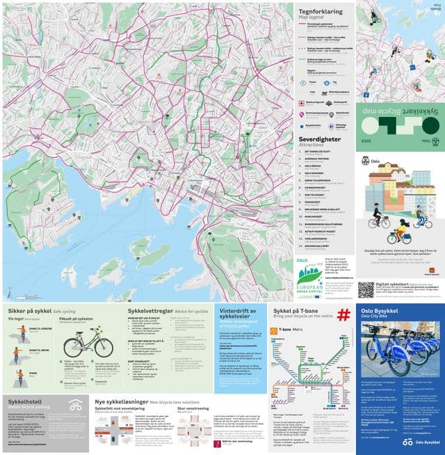
Oslo bike lane map

Map of Oslo bike lanes

The Oslo bike lane map shows all the bike routes of Oslo. This bicycles lanes map of Oslo will allow you to easily plan your routes with a bike in Oslo in Norway. The Oslo bike lanes map is downloadable in PDF, printable and free.

Oslo harbour promenade (Havnepromenaden) ties the city together from east to west and stretches nine kilometres along the city waterfront. Including some of Norway most famous buildings, the harbour promenade is an ideal route for those who want city sightseeing at a leisurely pace. During the nine-kilometre long promenade, you can experience everything from famous museums and historic buildings to modern landmarks like The Oslo Opera House, The Astrup Fearnley Museum, and Bjørvika Barcode, an area consisting of several narrow high-rise buildings of different heights and widths as you can see in Oslo bike lane map. Idyllic Bygdøy is a peninsula on the west side of the city centre. This is basically a residential area, but is also known for its many popular museums, cafes, beaches, and forest trails for both walking and cycling. One moment you can explore some of Norway greatest historical treasures at the Viking Museum or the Folk Museum, and the next you can take a dip from one of the best beaches the city has to offer. This is a gentle 7,5-kilometre long ride through a beautiful cultural landscape.

Although the City is constantly adding more and more of their signature red bicycle lanes, there are still far too many unprotected corridors, which is reflected in a poor perception of safety for new users. Rent a bike, bring your camera, and feel the fresh air on a trip around the Maridalsvannet lake. Follow the trail through a large and open cultural landscape on both sides of the water. Along the way, you will see several photogenic spots, such as the ruins after the Margareta Church or one of the many viewpoints around the lake as its shown in Oslo bike lane map. Oslo must continue full steam ahead with their commitments and investments if they are going to become a truly bicycle-friendly city in the coming years.

The Norwegian capital is very bike friendly, there are 180 kilometers (112 mi) of bike lanes and the locals prefer the bike as a mean of transport themselves as well. During our Oslo bike tours you will experience this beautiful Scandinavian city and its highlights from a unique perspective. Ride your bike along the must-see sights such as the Royal Palace and Gardens while a local guide introduces you to the story behind the city through fun anecdotes, which you can not find in any travel books. Today many of the city’s streets have separate bicycle lanes, and the conditions are getting better and better every year. They are currently in the process of making the center a truly car-free, people-oriented center city, with bike and walking paths heading out from a completely pedestrianized core of 1.3 square kilometers (0.5 square miles). This is in addition to the already existing 180 km (112 mi) bike lane network as its mentioned in Oslo bike lane map.