You can find on this page the Oslo streets map to print and to download in PDF. The Oslo roads map presents the road network, main roads, routes and motorways of Oslo in Norway.
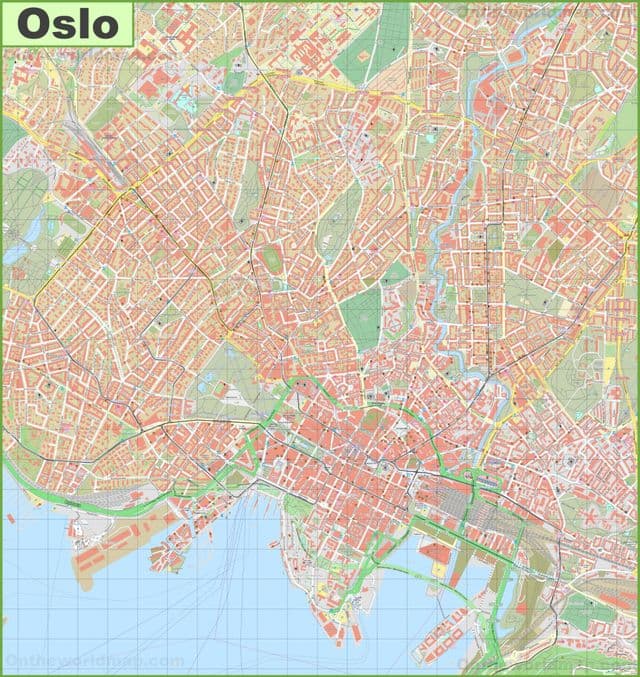
Oslo streets map

Map of Oslo streets

The Oslo streets map shows all street network and main roads of Oslo. This streets map of Oslo will allow you to find your routes through the streets of Oslo in Norway. The Oslo streets map is downloadable in PDF, printable and free.

Aasta Hansteens vei (1A-3, 2-10) lies in Stovner, Oslo. The road is a cul-de-sac from Fossumveien to Stovner police station. The street was named in 1977 after the women rights pioneer and artist Aasta Hansteen (born 10 September 1824, died 1908). Abbediengen terrasse (1A-3,2-4) is a cul-de-sac in the suburb of Ullern as you can see in Oslo streets map. The street runs northwards from the crossroads of Harbitzalléen / Abbedikollen. The street got its name in 1935 after the farm of Abbediengen. Abbediengveien (1-21, 2-8) is a street in the suburb of Ullern. The street runs from St. Edmunds vei to Harbitzalléen. The streets took its name in 1917 after the farm Abbediengen. Aasmund Vinjes vei (25-43, 26-40) is a road in Vinderen. The road is a villa road which runs from Rasmus Winderens vei to Slemdalsveien and Gaustad station . At the bottom of the road is a trail . The road was named after the author Aasmund Olavsson Vinje (born 1818, died 1870) in 1917.
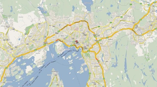
Damstredet is a small and narrow street, located in Oslo , in the borough of St. Hanshaugen . Damstredet has managed to survive intact as a charming part of town, with well-preserved and inhabited wooden houses, now one of the few streets that retains the then small town character of Oslo in a genuine manner. Damstredet was mostly built from 1810 to 1860, as part of the expansion of Oslo that begun at this time. The first house, Solberg , was erected in 1756 by sculptor Ole Meyer. His nephew, sculptor Andreas Hansen Meyer, took over in 1767, while his son Ole, also sculptor, erected another building in 1838. Geitmyrsveien (1-75, 20-76) is a street in Oslo situated in the borough of St. Hanshaugen as its shown in Oslo streets map. The street is c. 1.6 km long. It runs from Ullevålsveien along St. Hanshaugen park (1-33), and north of the park it separates the neighborhoods of Lovisenberg and Valleløkken (34-54 / 63A), and later between Lindern and Lovisenberg until it meets Kirkeveien / Griffenfeldts gate ( Oslo Ring Road 2) where it ends.

Heierstuveien (1-27, 2 (A) -42) is a street in the Norwegian capital Oslo Heierstuveien is located in the borough of Nordre Aker, more specifically on the outskirts of the residential area Korsvoll. Heierstuveien is approximately 285 meters long, and runs from the street Taasenveien to the street Carl Kjeldsens vei as its mentioned in Oslo streets map. Karl Johans gate (Karl Johan Street), named after King Karl Johan , is the main street of the city of Oslo. In its current route, it connects the main railroad station in Oslo and the Royal Palace , changing slightly its direction and width halfway between them, at Egertorget. Niels Juels Gate (1A-51, 2-70B) is a street in the Frogner district of Oslo in Norway. The street was built in 1879 and was named after the admiral Niels Juel (1629–97). Streets in the vicinity include Svoldergata, Drammensveien, Bygdøy allant, Colbjørnsens gate, Gyldenløves gate and Briskebyveien. In 1932 the Indian embassy was built on the street and was designed by Gudolf Blakstad and Herman Munthe-Kaas

Oslo roads map

Map of Oslo roads

The Oslo roads map shows all road network and highways of Oslo. This roads map of Oslo will allow you to find your routes through the roads and motorways of Oslo in Norway. The Oslo roads map is downloadable in PDF, printable and free.

Norwegian National Road 161 ( Norwegian : Riksvei 161 , also referred to as Ring 2 or "Kirkeveiringen") is an important ring road and surface street through densely populated parts of Oslo , Norway. The entire route is signposted as Ring 2, not National Road 161 as you can see in Oslo roads map. It stretches from Skøyen to Lodalen, a length of 9.7 km. The most important locations along the route are Skøyen , Frogner , Majorstuen , Lindern , Sagene , Carl Berners Plass, Tøyen and Galgeberg. Important institutions like the Frogner Park , the Norwegian Broadcasting Corporation , Ullevål University Hospital and the University of Osloare situated along or near the road. The name of streets are Drammensveien — Halvdan Svartes gate — Kirkeveien — Griffenfeldts gate — Marcus Thranes gate — Christian Michelsens gate — Finnmarkgaten — Kjølberggaten — Åkebergveien — St. Halvards gate — Kværnerveien.

Ring 2 is used by both cars and public transportation . The traffic on the route is separated only with traffic lights and roundabouts . The road is connected to major highways such as European route E18 , National Road 4 and National Road 190 as its shown in Oslo roads map. Major parts of Ring 2 are heavily congested during peak hours , because of low capacity and many large intersections. The route was originally planned to have 4 lanes, but several parts have only 2 lanes. The entire route is a priority road and the speed limit is 50 km / h. There are some parking garages situated on the western parts of the route. The gas stations along the road are situated on Skøyen, Marienlyst, Fagerborg, Lindern, Carl Berners Plass and Tøyen.

The Ring 3 or Riksvei 150 (formerly known as Store Ringvei ) is a major highway in Oslo , Norway. The numerous pre-existing roads orbiting the most densely populated areas of Oslo now have become a beltway limited-access road from its starting point at Ryen , through the Sinsen interchange , and to Lysaker in Bærum as its mentioned in Oslo roads map. The Sinsen interchange, where Ring 3 meets Trondheimsveien was opened in 1962. The increase in traffic was greater than the capacity of the junction, and thus a bridge was constructed that redirected Trondheimsveien above the roundabout. Further restructuring was done in 1992, when a local tramway line was redirected outside of the interchange, and in 1994, when Riksvei 150 was directed below the roundabout. The Norwegian Public Roads Administration plans to connect the Løren tunnel, a planned tunnel over Riksvei 150, with the Sinsen interchange in late 2008.