You can find on this page the Oslo transport map to print and to download in PDF. The Oslo transportation map presents the transports network and transport zones of the transit of Oslo in Norway.
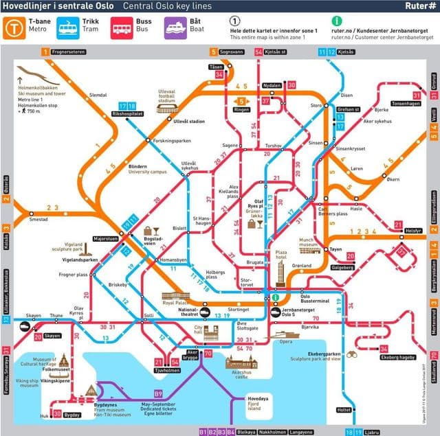
Oslo transports map

Map of Oslo public transports

The Oslo transport map shows all means of transportation in Oslo. This transports map of Oslo will allow you to move easily with public transport of Oslo in Norway. The Oslo transportation map is downloadable in PDF, printable and free.

Oslo transport managed by Ruter. This includes the six-line Oslo Metro, the world most extensive metro per resident, the six-line Oslo Tramway and the eight-line Oslo Commuter Rail as you can see in Oslo transport map. The tramway operates within the areas close to the city centre, while the metro, which runs underground through the city centre, operates to suburbs further away; this includes two lines that operate to Bærum, and the Ring Line which loops to areas north of the centre. Oslo Central Station acts as the central hub, and offers train services to most major cities in southern Norway as well as Stockholm and Gothenburg in Sweden. The Airport Express Train operates along the high-speed Gardermoen Line. The Drammen Line runs under the city centre in the Oslo Tunnel. Some of the city islands and the neighbouring municipality of Nesodden are connected by ferry. Daily cruiseferry services operate to Copenhagen and Frederikshavn in Denmark, and to Kiel in Germany.
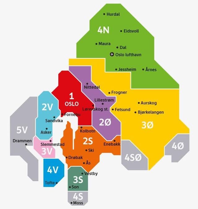
The best way to get around Oslo is on the trams or buses, as they are widely available and conveniently connect passengers to points throughout the city. When you arrive at Oslo Airport (OSL), you can take a train, bus, taxi or rental car into the city center. The T-bane metro system is also available downtown, though its network is limited compared to the trams and buses as its shown in Oslo transport map. Meanwhile, walking and biking are viable (and affordable) options for shorter treks on warmer days. This city is great for strolling, and luckily, many attractions are within walking distance of one another. But if you are visiting in the chillier months, you will probably want to look into using public transportation. Trains: Best suited for commuters and business travel. Metro (T-Bane): Holmenkollen ski jump, Frognerseteren, Ullevaal Stadium. Tram: Ekeberg Park, Barcode, Aker Brygge, Vigeland Park. Bus: Bygdøy museums. Ferry: Oslofjord islands.

When you need to buy tickets, you will find machines outside Oslo Central Station and in most of the city Narvesen and 7-Eleven shops as its mentioned in Oslo transport map, as well as most bus and tram stops. The fastest and most convenient way of getting tickets, however, is through the Ruter mobile app. A single ticket costs 36 NOK and is valid for 60 minutes. This is the most basic option, and one of the most economical if you are just taking a short trip and know where you are going in advance. If you need to travel to more zones, the price goes up accordingly. It pays to plan, as a single ticket bought from the driver costs 56 NOK. One important thing to point out is that you should always travel with a ticket. The fine for not having a valid ticket is 1 150 NOK.

Oslo zone map

Map of Oslo zones

The Oslo zone map shows all transport zones in Oslo. This zone map of Oslo will allow you to know the prices of public transport of Oslo in Norway. The Oslo zones of transports map is downloadable in PDF, printable and free.

All Ruter fares are determined by the zone you travel in. Zone 1 comprises all of Oslo, so if you plan on staying in the city for the duration of your visit, purchase a Zone 1 ticket as you can see in Oslo zone map. Single rides on any mode of public transportation, including T-bane trains, cost 35 kroner (about $4) for adults and 18 kroner (approximately $2) for children and seniors. Tickets that include unlimited rides within a 24-hour or seven-day period are available as well for 53 to 249 kroner (or $6 to $30) per person. For those with a timed Oslo Pass, all transportation fees (excluding train rides to and from the airport) are covered by pass fees.

Your ticket is valid on a limited number of passenger ferries that serve the small islands of the Oslofjord. They all fall within zone 1 as its shown in Oslo zone map. That includes Hovedøya, Lindøya, Nakholmen, Bleikøya, Gressholmen and Langøyene. These ferries all leave from the well-marked pier in front of Oslo City Hall. Some commuter ferries also link Oslo with Nessoden and other towns further down the Oslofjord. You will find these from a neighbouring pier closer to Aker Brygge. These ferries will require at least a two-zone ticket. The whole city of Oslo falls into Zone 1, ensuring you know what you will pay, wherever you are going.

The price for your journey is calculated based on the number of zones you travel through. The zones apply to both Ruter and Vy services in Oslo and parts of Viken (formerly Akershus). The entire Metro system is in Zone 1 as its mentioned in Oslo zone map. In zone 5V we operate bus routes 251 and 261. If you are travelling to/from zone 5V, we recommend you purchase your ticket from the public transport provider Brakar in the BrakarBillett app. With this ticket you can transfer to other routes in zones 3V, 4V and 5V. You cannot use a Brakar travelcard on routes 251 and 261. Brakar route 71 operates between Asker and Drammen. If you have bought a single ticket on board a Brakar service, this entitles you to transfer to a Ruter service, and vice versa. However, you cannot use a Brakar travelcard on our services. This is because Ruter ticket machines are unable to activate or read Brakar tickets, and vice versa.